7 ways to report severe weather to NWS without ham radio

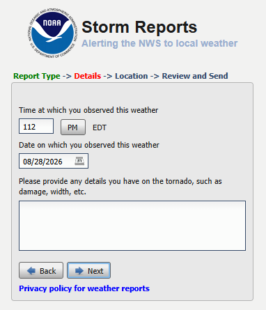
A screen shot of an NWS web form for reporting severe weather.

When the National Weather Service (NWS) started its Skywarn program in the 1960s, the first participants were licensed amateur (ham) radio operators. While many ham radio operators remain active in the program, the Skywarn storm spotters of today have many ways other than ham radio to send their reports. This article covers some of those communication channels for the benefit of spotters who don’t have ham radio licenses and for hams who need to send reports when their local on-air Skywarn networks are not active.

Phone calls

When a Weather Bureau meteorologist started the first ham radio Skywarn network after the Palm Sunday tornadoes of 1965, few people had car phones. Now, approximately 97% of the US population carries or owns a cell phone of some kind, according to data from the Pew Research Center. To report a tornado, funnel cloud, wind damage, etc. directly to an NWS weather forecast office (WFO), a trained storm spotter need only dial that office. Most WFOs have set aside a phone line for the sole purpose of receiving spotter reports.

A phone call gets attention in the WFO faster than most other reporting methods, so dialing the WFO is probably the best choice for the most dangerous sightings, like funnel clouds and tornadoes.

To keep people from using spotter phone numbers for other purposes, WFOs do not usually make them available on the web or other public communications. They usually provide special phone numbers during local storm spotter training classes. If you’ve taken the spotter course and misplaced the number, contact your local WFO now (via a number on the WFO’s website), tell them when you took the Skywarn training, ask for the number, and store it in your phone.

Alternatively, if you are a member of Spotter Network (see below), that organization’s “Submit Report” web page usually provides the spotter phone number for the appropriate WFO, based on your location.

NWS web forms

Any spotter who has access to the web (including via a mobile phone) may enter a report on a web form for any WFO. The URL is the same, no matter where you are: https://inws.ncep.noaa.gov/report/.

Spotter Network

Spotter Network, Inc. is a non-profit organization that is dedicated to bringing storm spotters, storm chasers, coordinators and public servants together in a seamless network of information. Storm spotters who join the organization and complete its online training may submit their reports via a form on the Spotter Network website. When the website determines the spotter’s location, it displays the location and phone number of the appropriate NWS office. That gives the member the option of calling the WFO for more urgent reports or completing the form. Spotter Network forwards data from its web form directly to the NWS.

X.com (Twitter)

Most WFOs have accounts on the social network formerly known as Twitter. Tagging your local WFO in a tweet is a great way to send a photo to supplement your report. It’s important to remember, however, that a tweet might not get noticed immediately, so a phone call is better for something like a funnel cloud or tornado. To find the correct X.com username to tag, search X.com for “NWS (office name).” For example, a search for “NWS Northern Indiana” reveals that the tag you should include in a tweet for that office is “@NWSIWX.” Don’t assume, however, that all WFOs use their three-letter IDs in their X account names. The Indianapolis office, for example, uses “@NWSIndianapolis,” not “@NWSIND.”

Facebook

Facebook is another way to send photos of severe weather or its impacts. Some NWS meteorologists have told me, however, that during severe weather, their offices don’t always have time to check Facebook often, making it a poor way to report a tornado. Facebook is well-suited, however, for sending photos of storm damage after a storm passes. Such photos can help WFOs decide where to send survey teams the next day. Search Facebook for the page that your local WFO operates. When you get there, post your report as a comment under an existing post on the page.

mPING

Meteorological Phenomena Identification Near the Ground (mPING) is a project to collect weather information from the public through their smart phones or other mobile devices. The free mPING iOS and Android mobile apps were developed through a partnership between the National Severe Storms Laboratory, The University of Oklahoma and the Cooperative Institute for Mesoscale Meteorological Studies. Anyone may download the apps from the Apple App Store or Google Play. Among the weather phenomena that mPING users may report are tornadoes, hail, storm damage and winter weather impacts. The reports use the mobile device’s GPS unit to include the exact location in the report and to route the report to the appropriate WFO. Some other apps, like RadarScope incorporate mPING so users can send reports without changing apps.

Email

Every WFO has a general email address. Meteorologists eventually see messages sent to those addresses. It’s unlikely, however, that such an email message will receive immediate attention, especially during severe weather. This makes email better for after-the-fact damage reports than for tornado reports. To find a WFO’s general email address, scroll to the bottom of the WFO’s web page (e.g. www.weather.gov/ind) and click on the link that reads, “Comments? Questions? Please Contact Us.”

Indiana weather alerts via social media

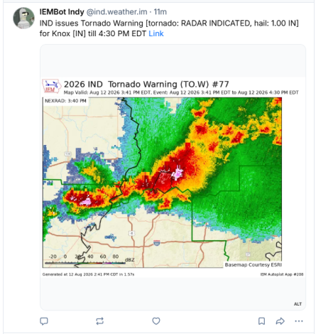
A screen shot of a tornado warning for Knox County, Indiana as it appeared on Bluesky after IEMbot automatically posted it.

I have for many years recommended having multiple sources of severe weather alerts and I have previously blogged about the best sources. Although social media is not the best way to receive information about impending severe weather, it’s one of many tools that can improve your awareness.

When I’m available, I share information such as mesoscale discussions, watches, etc. on various social media channels. I’m rarely available, however, to share National Weather Service (NWS) warnings in a timely manner. Fortunately, such warnings get posted automatcially to certain social media platforms by bots created and operated by Iowa State University’s Iowa Environmental Mesonet.

To find them, you must know which NWS weather forecast office (WFO) provides warnings for your county and you need to know the social media accounts in which that WFO’s alerts get automatically posted.

Start by finding your county on the list below to learn which WFO serves that county. Beneath that list are lists of accounts to follow on each of severel differnet social media platforms.

Indiana CountyWFO
AdamsNorthern Indiana (IWX)
AllenNorthern Indiana (IWX)
BartholomewIndianapolis (IND)
BentonChicago (LOT)
BlackfordNorthern Indiana (IWX)
BooneIndianapolis (IND)
BrownIndianapolis (IND)
CarrollIndianapolis (IND)
CassNorthern Indiana (IWX)
ClarkLouisville (LMK)
ClayIndianapolis (IND)
ClintonIndianapolis (IND)
CrawfordLouisville (LMK)
DaviessIndianapolis (IND)
DearbornWilmington, OH (ILN)
DecaturIndianapolis (IND)
DeKalbNorthern Indiana (IWX)
DelawareIndianapolis (IND)
DuboisLouisville (LMK)
ElkhartNorthern Indiana (IWX)
FayetteWilmington, OH (ILN)
FloydLouisville (LMK)
FountainIndianapolis (IND)
FranklinWilmington, OH (ILN)
FultonNorthern Indiana (IWX)
GibsonPaducah, KY (PAH)
GrantNorthern Indiana (IWX)
GreeneIndianapolis (IND)
HamiltonIndianapolis (IND)
HancockIndianapolis (IND)
HarrisonLouisville (LMK)
HendricksIndianapolis (IND)
HenryIndianapolis (IND)
HowardIndianapolis (IND)
HuntingtonNorthern Indiana (IWX)
JacksonIndianapolis (IND)
JasperChicago (LOT)
JayNorthern Indiana (IWX)
JeffersonLouisville (LMK)
JenningsIndianapolis (IND)
JohnsonIndianapolis (IND)
KnoxIndianapolis (IND)
KosciuskoNorthern Indiana (IWX)
LaGrangeNorthern Indiana (IWX)
LakeChicago (LOT)
LaPorteNorthern Indiana (IWX)
LawrenceIndianapolis (IND)
MadisonIndianapolis (IND)
MarionIndianapolis (IND)
MarshallNorthern Indiana (IWX)
MartinIndianapolis (IND)
MiamiNorthern Indiana (IWX)
MonroeIndianapolis (IND)
MontgomeryIndianapolis (IND)
MorganIndianapolis (IND)
NewtonChicago (LOT)
NobleNorthern Indiana (IWX)
OhioWilmington, OH (ILN)
OrangeLouisville (LMK)
OwenIndianapolis (IND)
ParkeIndianapolis (IND)
PerryLouisville (LMK)
PikePaducah, KY (PAH)
PorterChicago (LOT)
PoseyPaducah, KY (PAH)
PulaskiNorthern Indiana (IWX)
PutnamIndianapolis (IND)
RandolphIndianapolis (IND)
RipleyWilmington, OH (ILN)
RushIndianapolis (IND)
St. JosephNorthern Indiana (IWX)
ScottLouisville (LMK)
ShelbyIndianapolis (IND)
SpencerPaducah, KY (PAH)
StarkeNorthern Indiana (IWX)
SteubenNorthern Indiana (IWX)
SullivanIndianapolis (IND)
SwitzerlandWilmington, OH (ILN)
TippecanoeIndianapolis (IND)
TiptonIndianapolis (IND)
UnionWilmington, OH (ILN)
VanderburghPaducah, KY (PAH)
VermillionIndianapolis (IND)
VigoIndianapolis (IND)
WabashNorthern Indiana (IWX)
WarrenIndianapolis (IND)
WarrickPaducah, KY (PAH)
WashingtonLouisville (LMK)
WayneWilmington, OH (ILN)
WellsNorthern Indiana (IWX)
WhiteNorthern Indiana (IWX)
WhitleyNorthern Indiana (IWX)

Bluesky

If you use the social media platform Bluesky, follow the IEMbot account below that’s associated with your WFO from the list above:

WFOBluesky IEMbot account
Chicago@lot.weather.im
Indianapolis@ind.weather.im
Louisville@lmk.weather.im
Northern Indiana@iwx.weather.im
Paducah@pah.weather.im
Wilmington, Ohio@iln.weather.im

X.com (formerly Twitter)

On X.com, you can follow two different accounts for each WFO. Posts in each WFO’s official account are created manually by NWS meteorologists as they have time. Posts in the IEMbot account are created automatically from the alerts that the WFO creates.

WFOX.com official accountX.com IEMbot account
Chicago@NWSChicago@iembot_lot
Indianapolis@NWSIndianapolis@iembot_ind
Louisville@NWSLouisville@iembot_lmk
Northern Indiana@NWSIWX@iembot_iwx
Paducah@NWSPaducah@iembot_pah
Wilmington, Ohio@NWSILN@iembot_iln

Mastodon

Iowa Environmental Mesonet does not appear to have created IEMbot accounts on Mastodon, but my Mastodon account automatically posts IEMbot data for every Indiana county. You may follow it at @jayfarlow@wx.social.

Facebook

I”m not aware of any Facebook account that automatically posts all the warnings of WFOs that serve Indiana. In addition, Facebook’s algorithm can create significant delays. Each WFO has it’s own Facebook account (below) to which meteorologists manually post valuable information, so these are nonetheless worth following.

WFOFacebook page
Chicagohttps://www.facebook.com/NWSChicago
Indianapolishttps://www.facebook.com/NWSIndianapolis
Louisvillehttps://www.facebook.com/NWSLouisville/
Northern Indianahttps://www.facebook.com/NWSNorthernIndiana/
Paducahhttps://www.facebook.com/NWSPaducah/
Wilmington, Ohiohttps://www.facebook.com/NWSWilmingtonOH/

Web

Every WFO also has its own web page that’s worth bookmarking and visiting on a regular basis.

Programming the Baofeng DM-32UV handheld DMR radio

In 2025, Fujian Baofeng Electronics Co., Ltd. invited me to write a series of posts for the blog on the company’s website about how to program its DM-32UV handheld DMR radio. I wrote seven posts, links to which appear below.

DMR presentation for Whitley Co. Club

This evening, I spoke to the Whitley County Amateur Radio Club about digital mobile radio (DMR). Here is a link to my presentation slides for reference:

Tornado strikes NW Allen County July 29

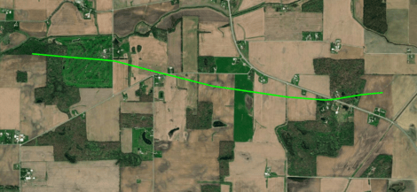
Path of a tornado that touched down just west of the Eel River Golf Course south of Churubusco and tracked rapidly east southeast, crossing US 33 before dissipating in a corn field west of Chase Road. NWS image.

The National Weather Service Northern Indiana weather forecast office (IWX) announced August 2 that it found evidence that a tornado did damage in eastern Whitley County and northwestern Allen County, Indiana at approximately 2:30 a.m. July 29.

“But wait,” you might say, “I never heard about a tornado warning for Allen County that day!” That’s because IWX didn’t issue a tornado warning for this storm. At the time of the tornado, however, a severe thunderstorm warning was in effect that included the words, “tornado possible.”

Most severe thunderstorm warnings do not automatically create alerts on your cell phone.

It’s not unusual for the kind of storm we had Saturday morning (a bowing “squall line”) to spawn weak tornados that appear and disappear before the National Weather Service can issue a warning. That’s why, when they warn us of a severe thunderstorm that could contain such tornados, they mention that a tornado is possible.

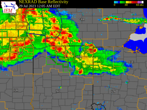
Weather radar loop slowing the bowing squall line that moved across Indiana early July 29.

It’s also one reason that it’s so important to know about and react appropriately to severe thunderstorm warnings, including those the National Weather Service issues in the middle of the night, when you’re sleeping. But that requires extra effort on your part, because most severe thunderstorm warnings do not automatically create alerts on your cell phone.

If you’ve ever been someplace covered by a tornado warning, you probably received a Wireless Emergency Alert (WEA) on your phone, even if you never installed a weather app. That’s because all modern smartphones come with WEAs enabled and all tornado warnings prompt WEAs.

The only severe thunderstorm warnings that trigger WEAs, however, are those in which the National Weather Service includes a “destructive” damage threat “tag.” They do that for storms that have either hail that’s at least 2.75 inches in diameter (baseball-sized) and/or 80 mph straight-line thunderstorm winds. According to Saturday morning’s severe thunderstorm warning, meteorologists expected winds of up to 60 mph and no large hail. That warning therefore did not trigger a WEA.

So, how can you know if a storm like Saturday’s is headed toward your home in the middle of the night, while you’re asleep? I know of two really good ways:

  1. Buy a weather alert radio and keep it near enough to your bedroom to wake you.
  2. Install a weather alert app, like Storm Shield, and configure it to alert you to severe thunderstorm warnings.

When the NWS issues a severe thunderstorm warning for your location, the best way to be safe is to do the same thing you’d do in a tornado warning. Move to the most interior room on the lowest level of your house. This will provide the best protection from a brief tornado, like the one that touched down July 29 and from straight-line thunderstorm winds dropping a tree limb on your house, which is what killed a woman in Ohio City, Ohio July 20.

W9LW’s TYT MD-380 codeplug programming guide

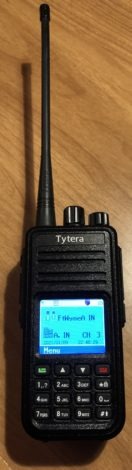
I have created a guide to help users of the TYT MD-380 handheld, DMR amateur radio create codeplugs for their radios.

The link below will provide the latest version of the document.

Download the guide.

W9LW’s Anytone AT-D878UV codeplug programming guide

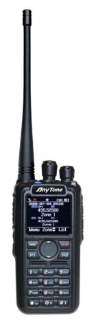
I have created a guide to help users of the Anytone AT-D878UV handheld, DMR amateur radio create codeplugs for their radios.

The link below will provide the latest version of the document, which I have updated since publishing the original version. Version 2.65, uploaded January 29, 2023, adds advice on matching the CPS version to the firmware version.

Download the guide.

W9LW’s RD-5R codeplug programming guide

Radioddity Baofeng RD-5R handheld DMR radio

I have created a guide to help users of the Radioddity/Baofeng RD-5R and DM-5R handheld, DMR amateur radios create codeplugs for their radios.

Version 3 of this guide combines and updates two previous guides into a single document.

Get the guide.

COVID-19 pandemic affects SKYWARN severe weather operations

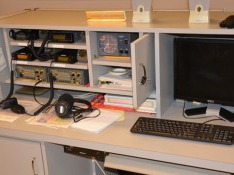
WX9IWX ham radio station at NWS Northern Indiana

Restrictions implemented to slow the spread of COVID-19 will affect one of the ways SKYWARN® storm spotters send reports to local National Weather Service (NWS) offices. Many NWS weather forecast offices (WFOs) have amateur (ham) radio equipment permanently installed. During severe weather events, volunteer ham radio operators operate that equipment to receive reports of tornadoes and other dangerous weather from fellow hams who are storm spotters.

Now, however, the NWS is forbidding anyone not directly connected with the agency from entering WFOs, according to NWS Northern Indiana warning coordination meteorologist Michael Lewis. That means that ham radio stations at WFOs are less likely to be on the air during severe weather events. Some NWS meteorologists have ham radio licenses and some of those might be able to sporadically operate WFO ham stations. But Lewis told me that to reduce exposure to disease, the NWS is trying to operate WFOs with as few people in the office as possible. This might mean that NWS meteorologists who have ham licenses will have no time to operate the ham radio equipment.

Ham radio operators will still be able to use their radios to report severe weather, but they’ll need someone other hams to relay those reports to their local WFOs. That’s where an internal NWS text chat system will be essential, Lewis said. The system is called NWSChat and access is limited a select population. That groups includes ham radio operators who serve as net control station operators. Local ham radio SKYWARN groups can (and should) designate such leaders to serve as liaisons between the radio networks and NWSChat.

Whether or not spotters have ham radio licenses, other ways to communicate reports continue to be available, including telephone calls to WFOs and Twitter tweets that include the appropriate WFO’s Twitter handle.

The voice communication app Zello can also be helpful to SKYWARN storm spotters. Unfortunately, Zello’s terms and conditions do not comply with federal government requirements, so NWS WFOs are prohibited from installing Zello on any government-owned devices. A specific Zello channel exists (“IWX SKYWARN”) for reports from areas covered by the Northern Indiana office. Because WFO staff are prohibited from using Zello, ham radio net control station operators, who have NWSChat accounts, plan to monitor the Zello channel as much as possible, to relay reports from spotters to the WFO.

All this could be tested tomorrow, March 19, when severe weather is forecast in much of Indiana.

Are weather radar apps dangerous?

One well-known meteorologist thinks they can lead untrained users to draw unsafe conclusions

Dr. Kevin Kloesel shows archived radar data from the 2011 Indiana State Fair stage collapse tragedy. The white “X” on his slide indicates the location of the fairgrounds. An outflow boundary (thin, blue line) is depicted ahead of a line of severe thunderstorms.

Anyone who makes decisions based on radar data displayed on mobile apps is essentially “acting the part of a meteorologist without the background,” and that will result in deaths, asserted meteorologist and certified emergency manager Dr. Kevin Kloesel, during the Ohio State University (OSU) Severe Weather Symposium March 28.

Kloesel, who works in the University of Oklahoma Office of Emergency Preparedness, was the final speaker of the day-long symposium, organized by OSU meteorology students.

A non-meteorologist will most likely be using a simple phone app, and tend to focus on the “scary colors” and lowest elevation tilt of the radar, Kloesel told symposium attendees.

As a case in point, Kloesel discussed a 2011 incident at the Indiana State Fair, where winds in advance of a severe thunderstorm caused the collapse of a temporary structure that held spotlights and other equipment above an outdoor concert stage, killing seven people.

Kloesel showed archived radar data from that night, beginning with an 8:35 p.m. scan (see photo above) that depicted a line of heavy precipitation and ahead of that, a thin line representing an outflow boundary. Meteorologists know that such boundaries can indicate gust fronts with strong but usually sub-severe (less than 58 mph) straight-line winds.

Kloesel displays archived radar data from 8:53 p.m. the night of the Indiana State Fair stage collapse. This data shows an outflow boundary apparently right over the fairgrounds, which are represented in Kloesel’s slide by a white “X.”

Archived radar data depict the outflow boundary directly over the fairgrounds at 8:53 p.m (see photo above).

The deadly collapse, however, happened at approximately 8:46 p.m., much earlier than most untrained users of radar data might expect, in part because the “scary colors” had not yet arrived. Even non-meteorologists who recognize outflow boundaries likely don’t know that gust fronts on the ground occur ahead of where outflow boundaries appear on radar.

Kloesel reminds attendees that radar data shows what is happening at the height of the radar beam, which can be quite different than what’s happening directly below that point.

This is because a radar beam rises in reference to the ground as it travels from its source antenna (see photo above). Radar images therefore show what’s happening at the height of the radar beam, not at the ground

Trained meteorologists understand that they cannot assume that what’s happening on the ground will be indicated by what the radar depicts at beam height. Most other users of radar data on mobile apps probably lack that understanding, Kloesel said.

It’s too easy for people to rely on weather data via a mobile app, Kloesel said rather than seek expert consultation. The disconnect between the availability of data and the ability to correctly interpret such data is what led Kloesel to assert that radar app use can be dangerous.

This information is of particular importance to anyone who is responsible for the safety of people attending any outdoor mass gathering. All such events and venues should rely on trained meteorologists, versus others’ interpretations of what they see on mobile apps.

One way event leaders can get such support is through the National Weather Service’s Impact-based Decision Support Services (IDSS). The best way for event organizers to access IDSS is usually through a local emergency manager (i.e. director of an emergency management or homeland security agency).

Kloesel shared a quote from a lawyer involved in a weather-related injury case, who said that such incidents are “preventable with prudent caution and control of events in the face of available meteorological information.”